
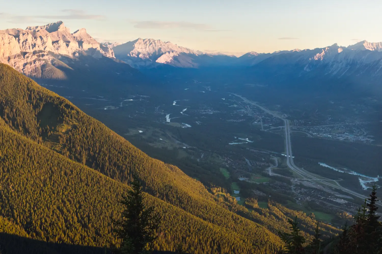
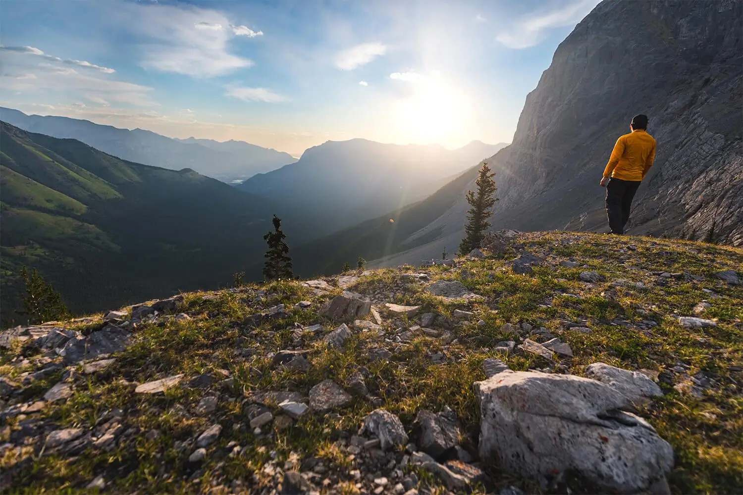
The secret is out; after being featured in the 1988 Winter Olympics, the small former mining town of Canmore has been attracting the throngs of tourists that had previously driven straight through on the way to Banff. Despite being only twenty minutes away, Canmore is a worthy destination all by itself. It’s also a perfect jumping-off point for countless hikes in Kananskis Country, an amalgamation of Alberta provincial parks that easily rival the beauty of Banff. Whether you’re exploring Canmore’s downtown shops or hiking its mountain landscapes, there’s tons to do on a trip to Canmore.
Nearly all of the hikes I’ve listed are located in Kananaskis Country, meaning that a valid park pass is required. Day passes can only be purchased online and are per day per vehicle, but if you’re staying six days or longer, it’s more cost-effective to just buy an annual pass instead.
When in the outdoors it’s important to avoid harmful practices such as disturbing plants or rock-stacking, or removing any natural object from flowers to rocks, as it’s important to leave the environment as natural as possible for the animals and for fellow hikers to enjoy in perpetuity. As many flowers as there are, there are few enough that if we all took one, then there wouldn’t be any left. Take only photos, leave only footprints.
I also highly recommend reading up on Leave No Trace principles before heading anywhere into the outdoors in general. Following these important principles basically means doing your best to leave beautiful places like Port Renfrew as good (if not better) than you found them, both for their preservation and for the enjoyment of other visitors.
Grassi Lakes
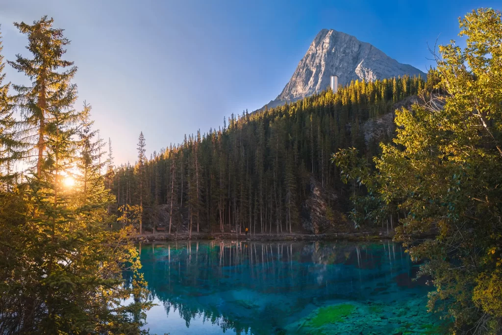
Distance: 3.8 km / 2.4 mi
Elevation Gain: 187 m / 614 ft
Hiking Time: 1-1.5 hrs
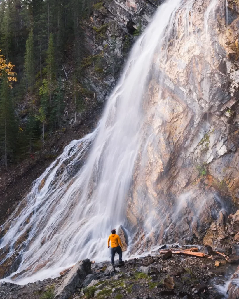
The Grassi Lakes hike is one of the easiest and most accessible hikes near Canmore. Tucked in the valley between Ha Ling Peak and EEOR, the two Grassi Lakes are like shining emerald gems. The short hike is one of the most popular things to do in the Bow Valley, and the trail leading up to Grassi Lakes also reveals spectacular views of Grassi Falls as well as over the valley below. There are actually two ways to get up to the lakes from the Grassi Lakes trailhead. The lower trail is the steeper one, utilizing wooden stairs to climb up close to the majestic Grassi Falls. This trail is by the far the more scenic, but it is usually pretty wet, and is closed in winter. The upper trail is technically an old access road, meaning that it’s wide and heads up at a consistent grade. There aren’t really any views until the top, but unlike the lower trail the upper trail is likeable year-round and by almost anyone. Most people choose to do the Grassi Lakes hike as a loop, taking one trail up and the other down. Which direction you go is up to you.
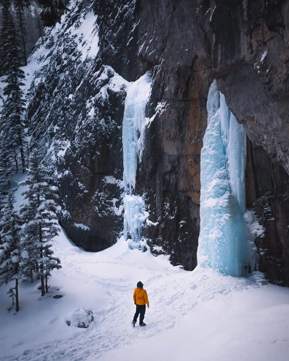
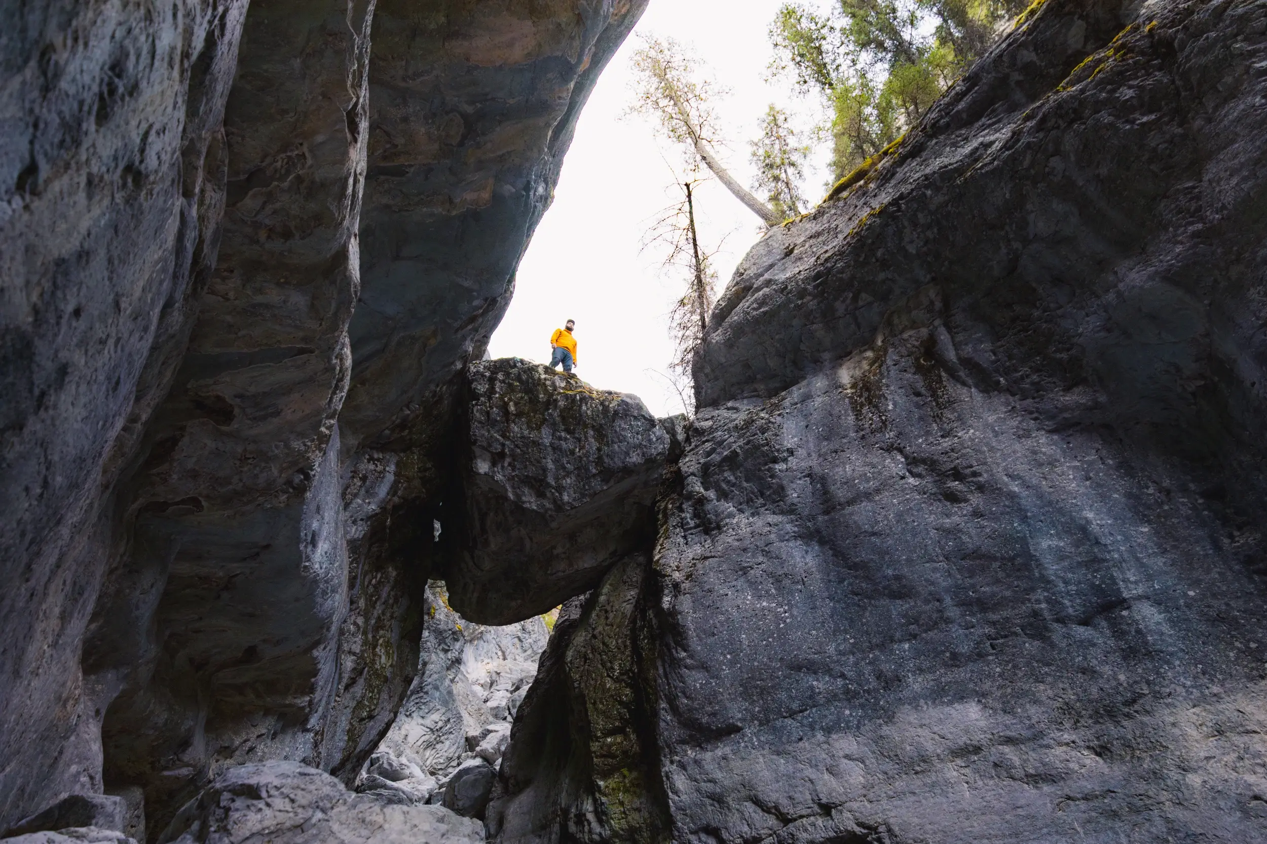
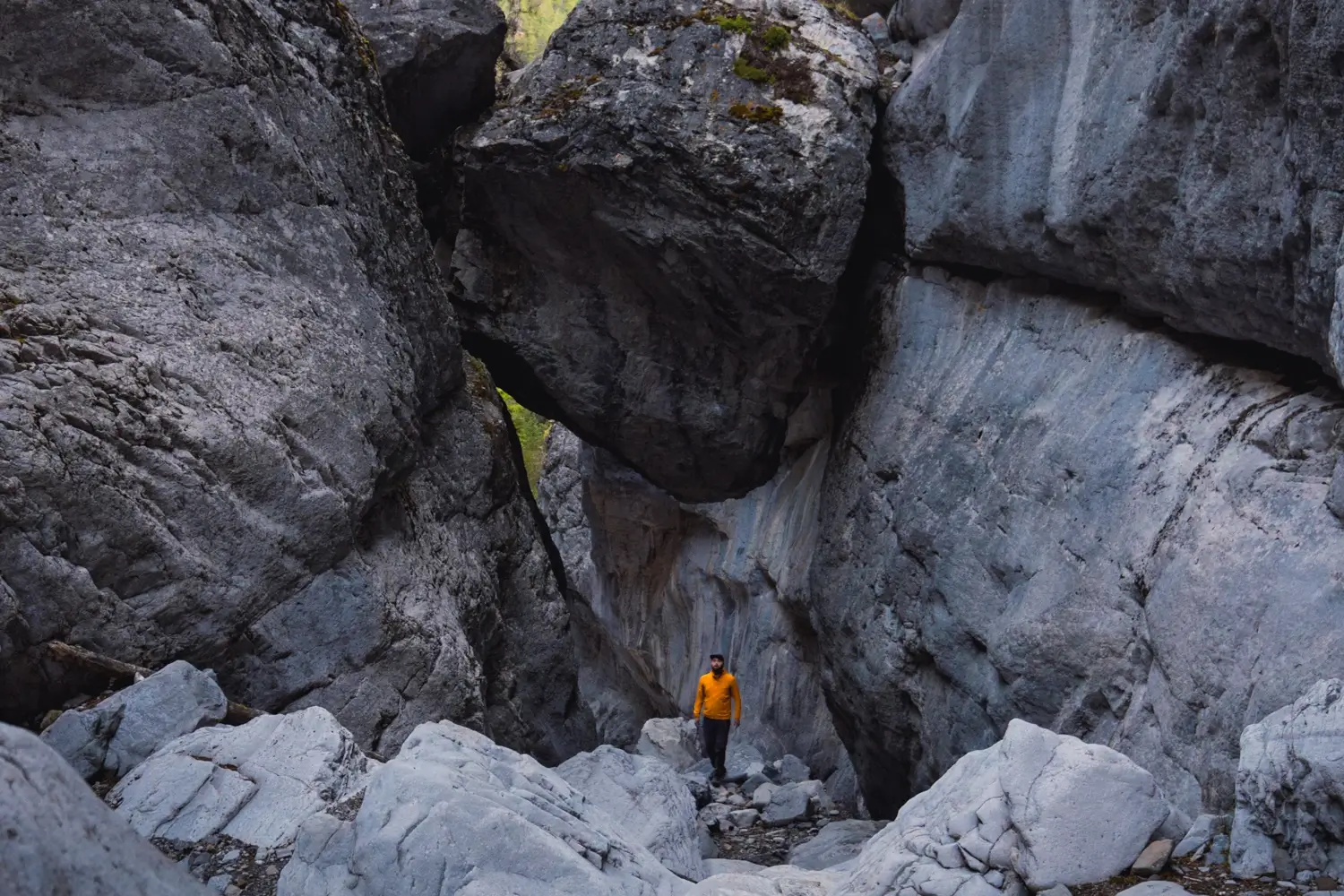
Grotto Canyon
Distance: 6.5 km / 4 mi
Elevation Gain: 325 m / 1066 ft
Hiking Time: 3 hrs
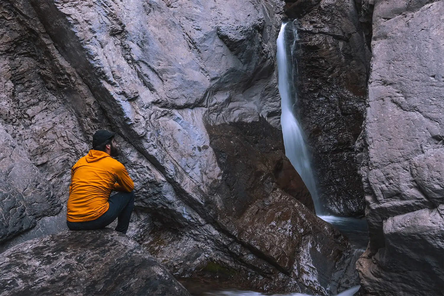
The first part of the trail leading to the canyon is bland and uninteresting, as it parallels the highway and passes closely by the Baymag processing plant, until finally reaching the Grotto creekbed and opening up to a gorgeous viewpoint of the Bow Valley beyond. This one of my favourite Bow Valley viewpoints that doesn’t require any real elevation gain. Once the trail enters the canyon though, and the rock walls rise up on either side, is where the walk becomes really interesting. Unlike some other canyon walls, there are no obstacles or boulders that really need to be climbed over, and the most challenging section is probably the short steep descent along the trail into the creekbed.
The walk into Grotto Canyon definitely rewards those who do their research and know where to look, as the walls of the canyon are home to some fascinating and ancient pictographs. Further up is the small (though difficult to approach – best enjoyed from a distance) waterfall that is all that remains of the night glacial meltwater that once carved the whole canyon. In the winter two other small drips turn into large ice pillars that are very photogenic. If continuing even further through the canyon, you’ll be taken to view of a large cave opening in the unusual-looking cliffs above. It’s possible for the brave to scramble up to the cave, but it is quite steep.
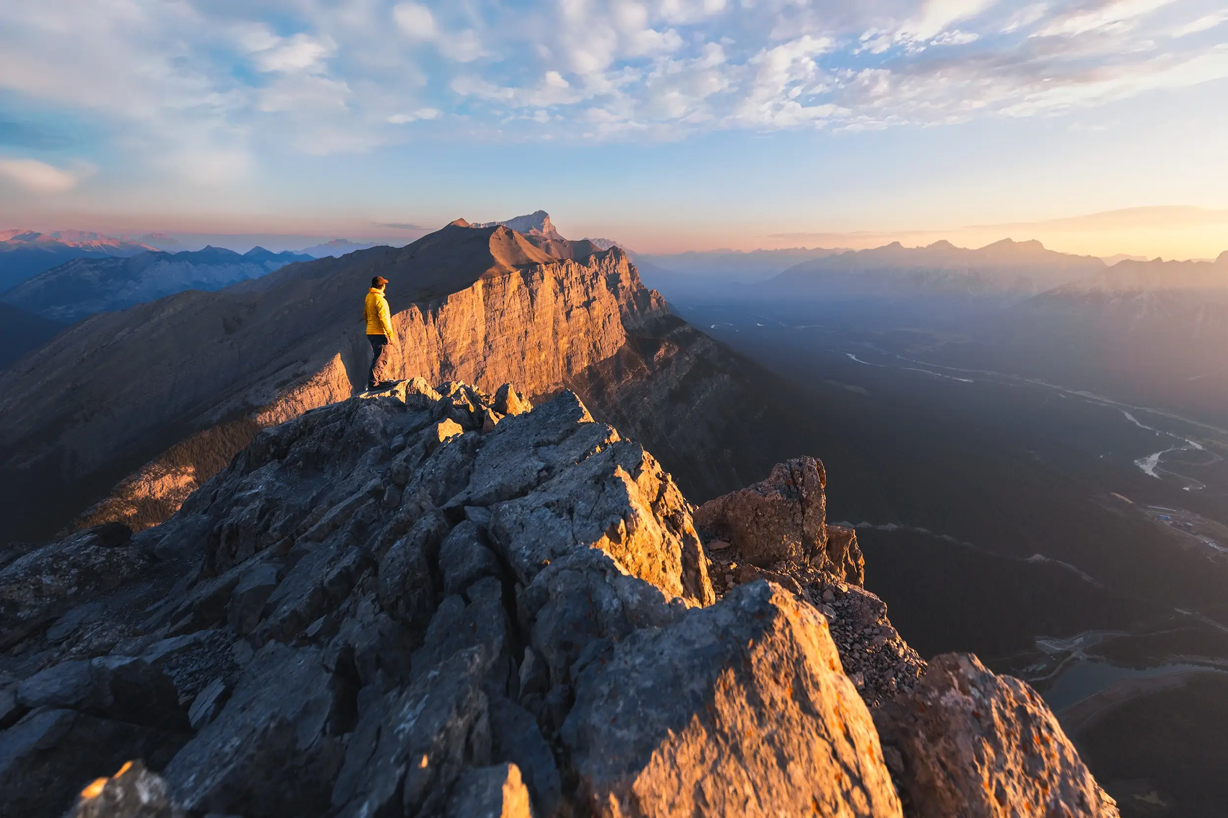
Ha Ling Peak
Distance: 8 km / 5 mi
Elevation Gain: 790 m / 2590 ft
Hiking Time: 3-4 hrs
Ha Ling Peak was known for more than a century as “Chinaman’s Peak” after the Chinese cook who first climbed in 1896. It wasn’t until 1997 that it was changed to his actual name. As the story goes, Ha Ling was bet $50 that he couldn’t make it up the peak in under ten hours. The next morning he did exactly that and was back in time for lunch. People were doubtful of his accomplishment however, and couldn’t actually see the flag he claimed to have planted on the top. So the next day he took an even bigger flag and climbed the mountain all over again!
I highly recommend tackling this Canmore hike in the morning, just like Ha Ling did. This is one of the busiest and most popular hikes in the region, and the parking lot and trail get packed at midday. Ha Ling Peak is one of the very few peaks in the Rockies that sees sunrise and sunset hikers nearly every day of the year. No matter what time you hike, you won’t have the trail entirely to yourself, but Ha Ling Peak is such a great hike that it doesn’t really matter.
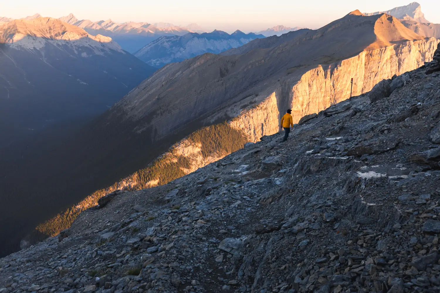
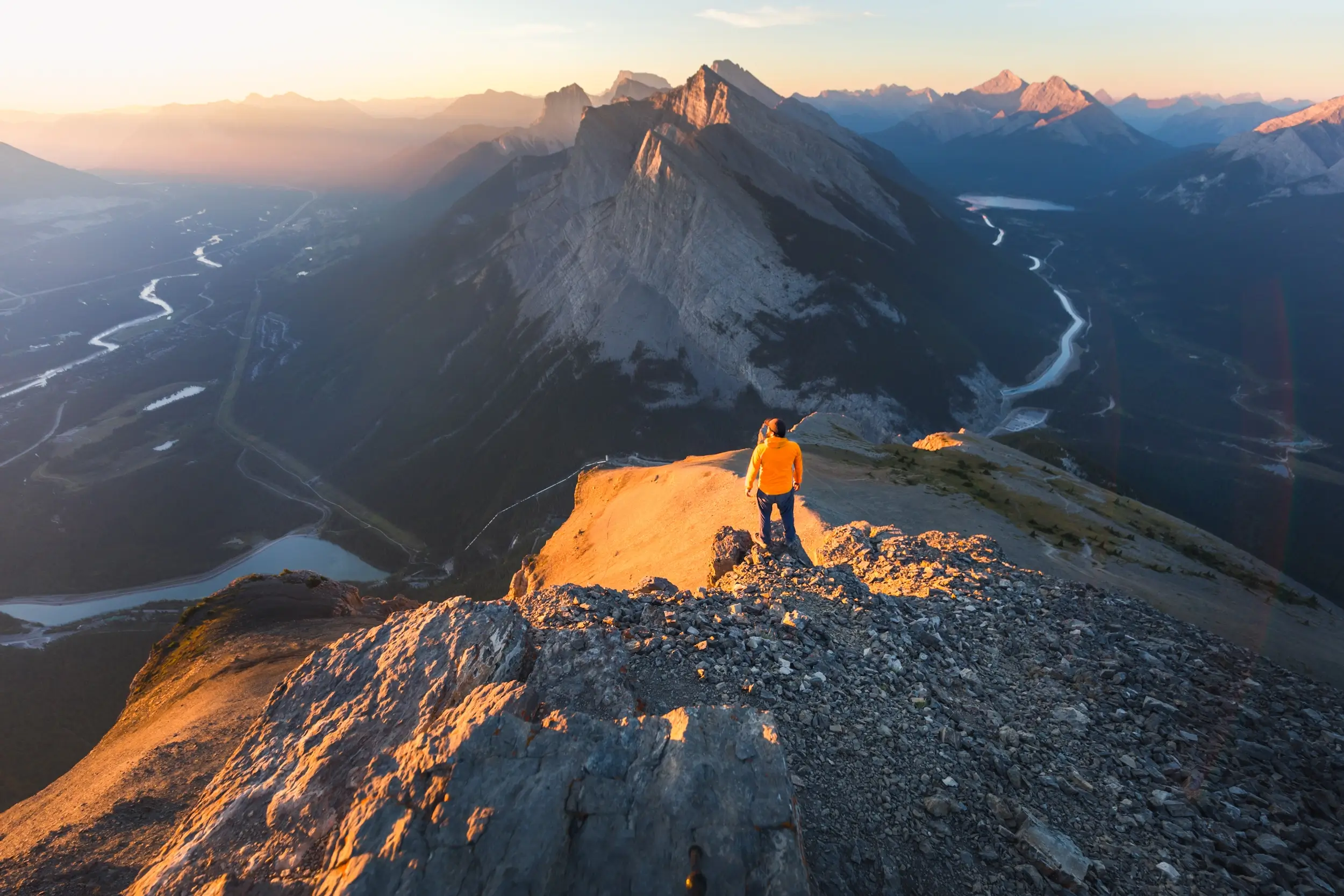
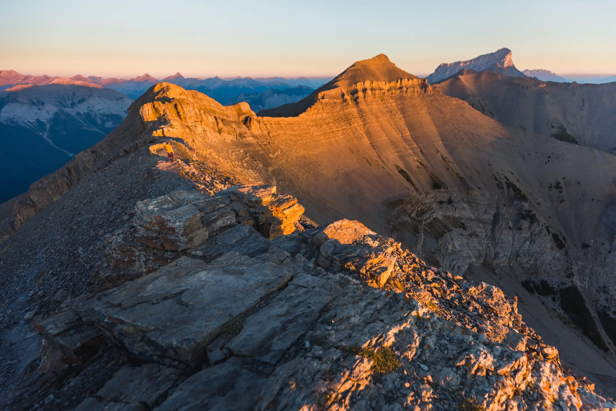
East End of Rundle
Distance: 5.7 km / 2.4 mi
Elevation Gain: 857 m / 2811 ft
Hiking Time: 3-4 hrs
While EEOR is not a super long hike (the consistently steep grade means that you get up surprisingly fast), it is made challenging by long sections of scree slog as well as several sections of mild scrambling, especially near the summit. As a result of not being an official Kananaskis Country hike, the trail is very braided and takes a million different parallel routes up the mountain, meaning some decision-making is required in order to pick the route that’s best for you. The trail has no signs or reliable flagging, so I highly suggest downloading a GPS track ahead of time (I recommend using either the GaiaGPS, CanTopo, or AllTrails apps) to make sure you’re generally on track, but I don’t recommend sticking to it religiously. There were plenty of times that the GPS track I used suggested I take a particular path when I could see an easier, safer, or more convenient alternative with my eyes.
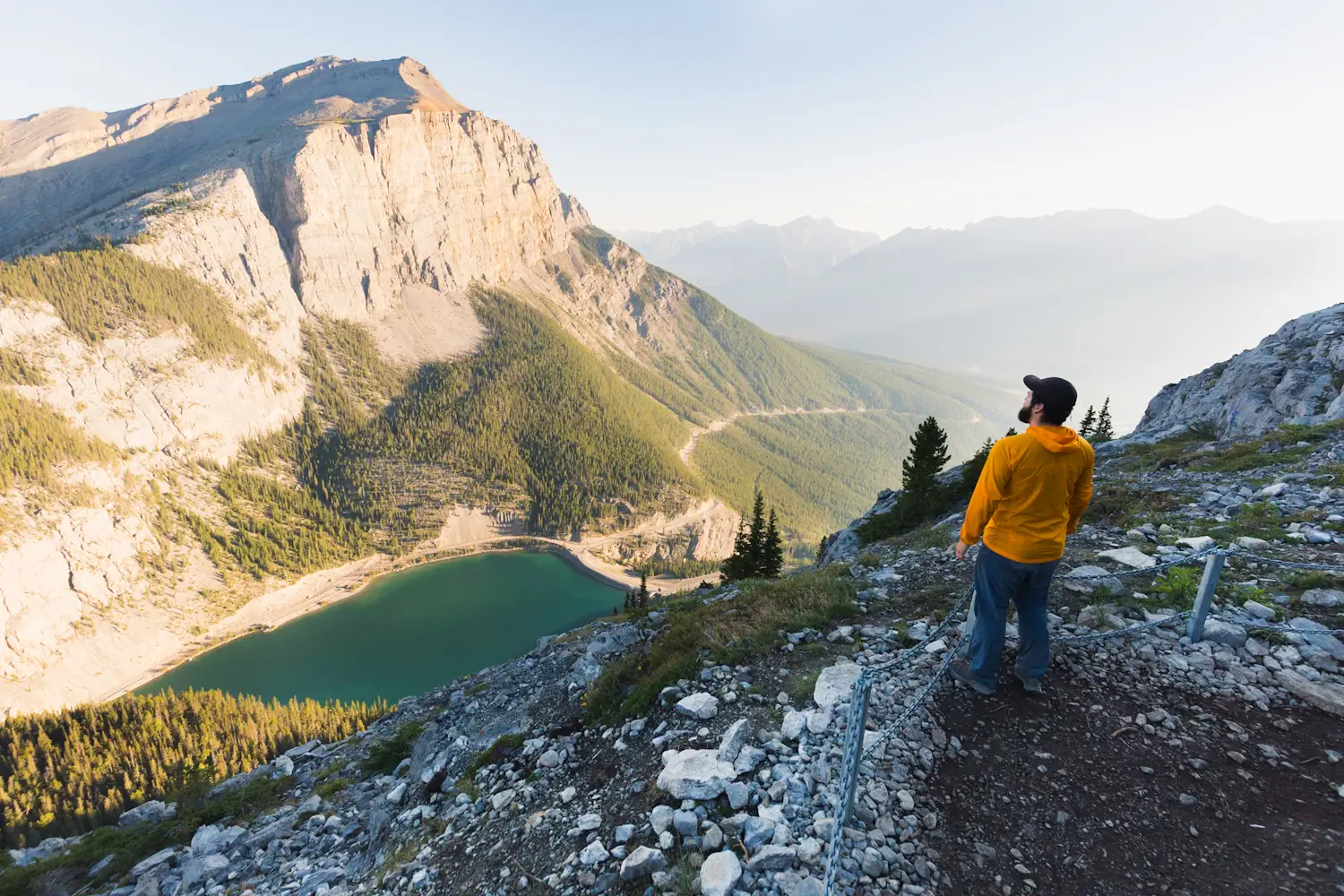
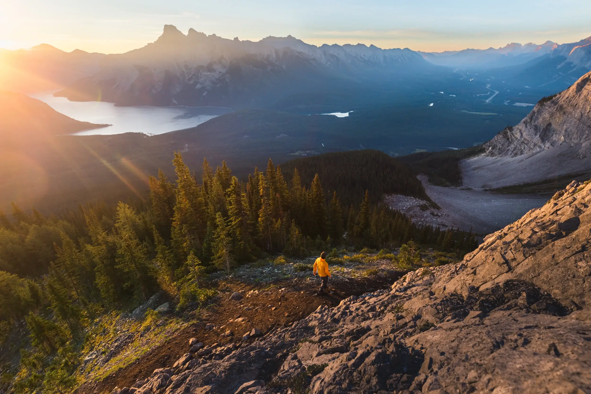
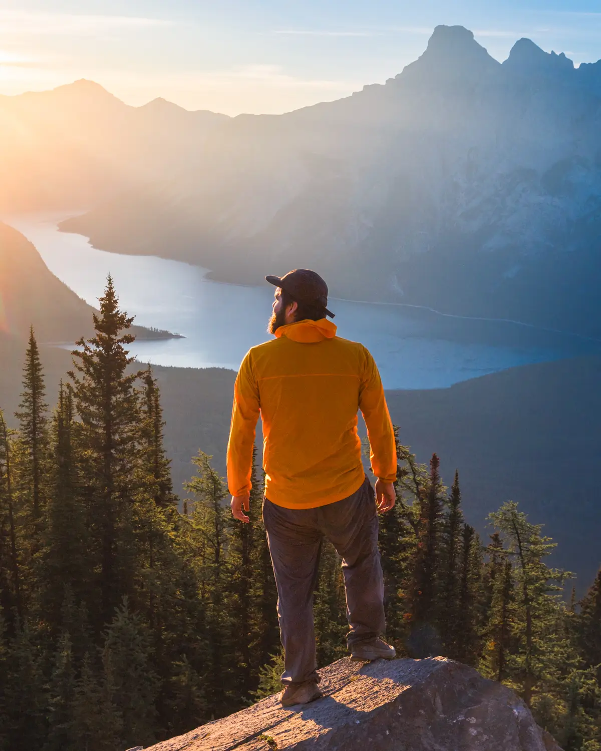
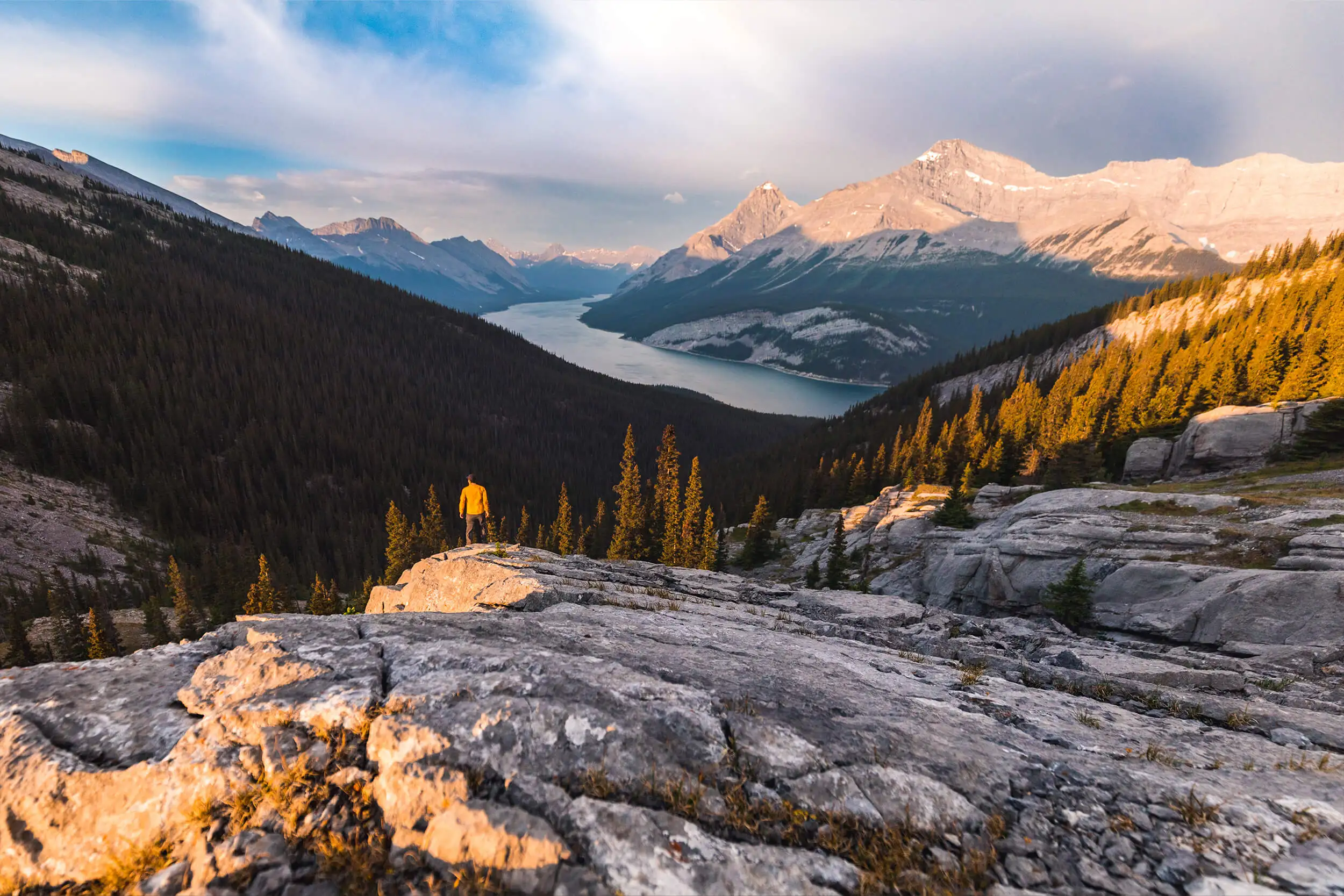
Wind Ridge
Distance: 13.9 km / 8.6 mi
Elevation Gain: 964 m / 3163 ft
Hiking Time: 5 hrs
Trail closure: The Wind Ridge hike is closed annually from December 1 – June 15 for protection of critical winter range for elk and bighorn sheep. If looking for a great hike to do during these months, please respect the closure and instead try any of a million other great hikes in the region.
Wind Ridge is one of the longer day hikes in the Canmore area, with a decently long approach to the base of the ridge before the trail starts ascending steeply. Once out of the trees and on the verdant grassy southern slopes of the ridge, views of the valley and surrounding peaks are revealed. The steady ascent uphill along the Ridgeline gets quite steep, but the views definitely help. The crux of the hike is probably a very short and easy scrambling section (only about two vertical meters) that most people should be able to do without a problem – otherwise it is possible to take a detour around this section. Otherwise the constant uphill grind is what makes this a moderate hike, but the views are well worth it. If you’re looking for an easier hike with similar views, I suggest the West Wind pass hike.
Heart Creek Bunker
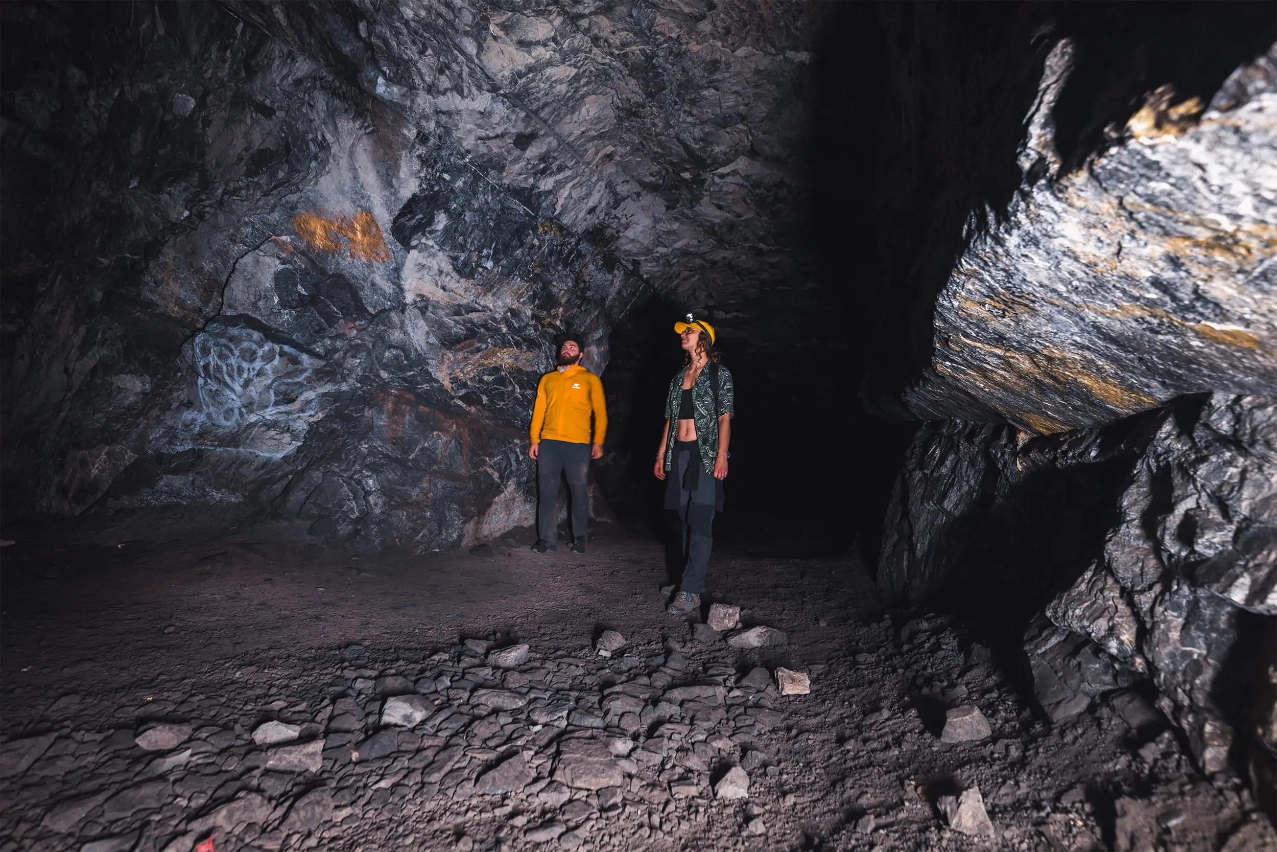
Distance: 4 km / 2.5 mi
Elevation Gain: 221 m / 725 ft
Hiking Time: 1 hr
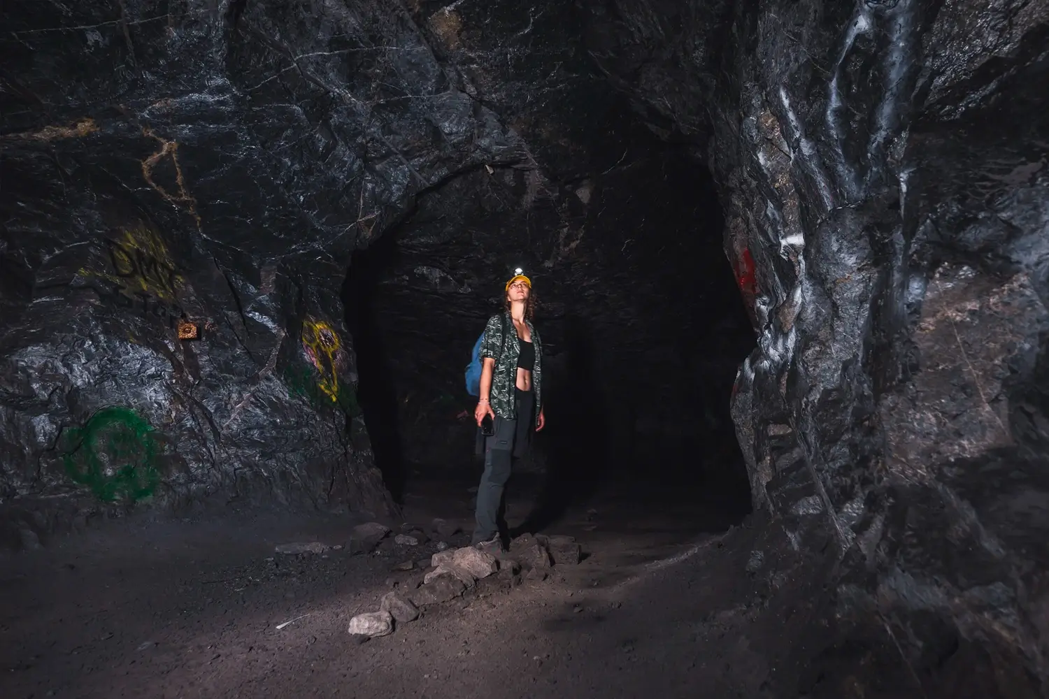
In 1969 Rocky Mountain Vaults and Archives received Alberta government permits to build access track and blast into the side of Mt McGillivray, high above the Trans-Canada Highway. Two brothers invested a quarter million in their dream of a high-tech space, complete with private vaults, a reception room, 24/7 security, meeting area, cooking facilities, and 3-foot thick reinforced sliding concrete doors.
Today the vault complex stands incomplete. A deep black hole reaches into the side of the mountain, rough-hewn graffiti-covered stone walls and ceiling forming a long corridor with small rooms branching off in either direction. The floor is made up of rocks and dust, with the occasional beer can or abandoned debris from an illegal fire. The walk to Heart Creek Bunker today is a short and easy one, and is one of those Kananaskis hikes that is doable all seasons of the year, and by hikers of all skill levels.
C-Level Cirque
Distance: 11.5 km / 7.1 mi
Elevation Gain: 774 m / 2539 ft
Hiking Time: 4 hrs
The way the rock of Cascade Mountain folds upward meant that mining the coal seams was literally an uphill battle, requiring shafts to be drilled into the mountain at higher and higher elevations to follow the seams. The uppermost level of the expansive mine workings, the C-Level operations, is what C-Level Cirque derives its name from. This large cirque and its lookout are located high up on Cascade Mountain’s eastern flank. The C-Level Cirque hike starts from what was once the Bankhead townsite, passing an abandoned house and numerous old mineshafts as it climbs up the side of the mountain. This part of the valley is particularly hospitable to fungi, and there are hundreds and hundreds of mushrooms of various types all along the side of the trail. Higher up, the C-Level Cirque trail reaches the steep talus slopes on the side of Cascade Mountain, home to countless pikas and marmots. From the top of the trail, the views towards Lake Minnewanka are stunning, as well as those looking southwards down the Bow Valley towards Canmore.
Quieter than other Banff hikes so close to the townsite (Tunnel Mountain or Sanson Peak), the C-Level Cirque hike in Banff is one of my favourite hikes to do in the area not only for the stunning views from the top, but for the diversity of terrain and smaller sights to see along the way.
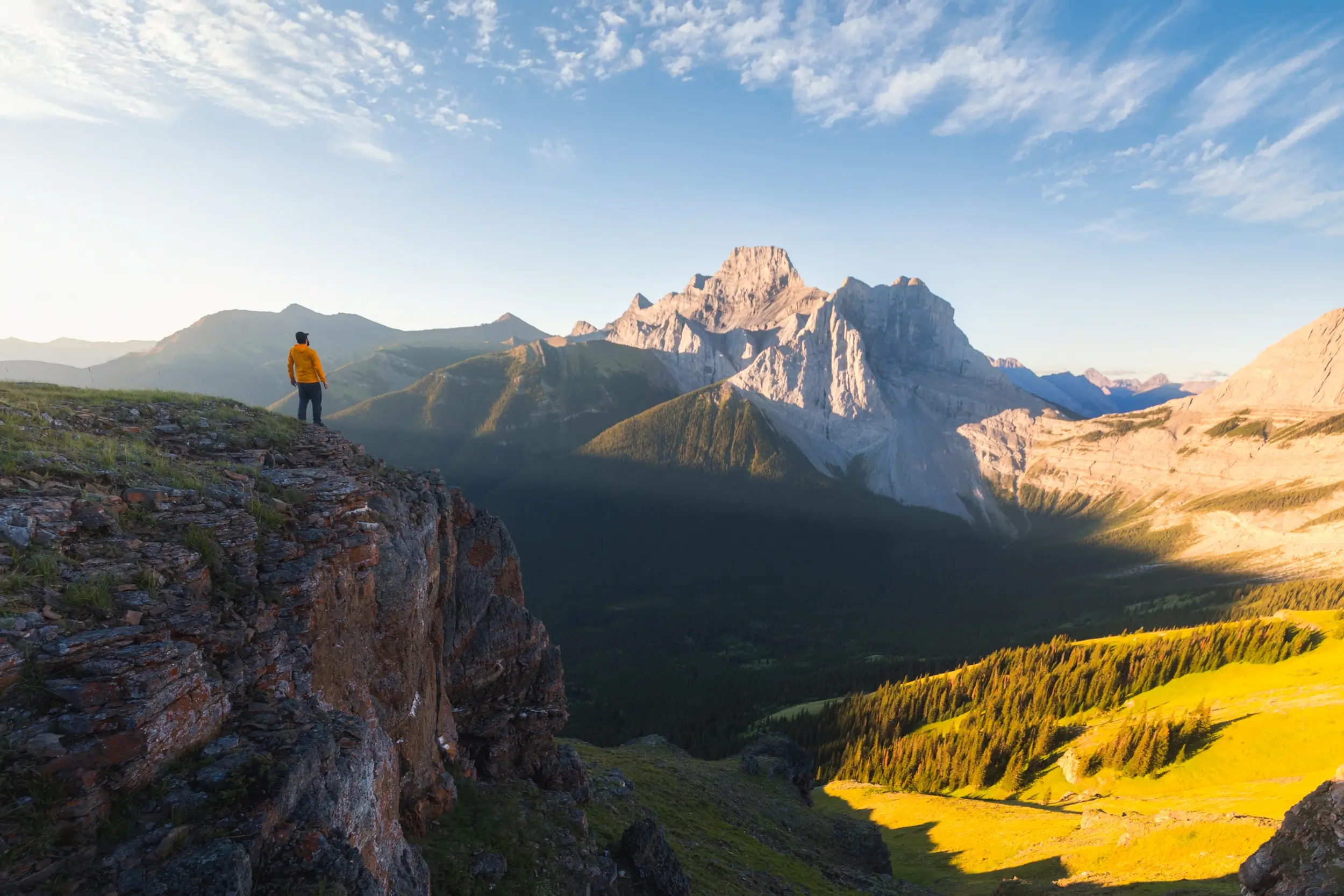
West Wind Pass
Distance: 3.8 km / 2.4 mi
Elevation Gain: 187 m / 614 ft
Hiking Time: 1-1.5 hrs
Trail closure: The West Wind Pass hike is closed annually from December 1 – June 15 for protection of critical winter range for elk and bighorn sheep. If looking for a great hike to do during these months, please respect the closure and instead try any of a million other great hikes in the region.
Nestled between soaring Rimwall and Windtower, West Wind Pass is a safer and easier objective compared to these and other peaks in the area. Hiking up West Wind Pass trail is relatively easy though at times trail braiding poses a bit of a challenge to navigation. The trail starts at the base of the valley near the Spray Lakes Reservoir and climbs sometimes steeply up the valley until reaching the high mountain pass. Views from the top include west over the Spray Valley as well as east towards Wind Ridge and the end of the Bow Valley with the great plains beyond.
West Wind Pass is a fantastic example of a shorter hike near Canmore that doesn’t compromise on views, making it perfect for families and beginner hikers or for more experienced hikers looking for a warmup before tacking some of the more challenging hikes in the region.
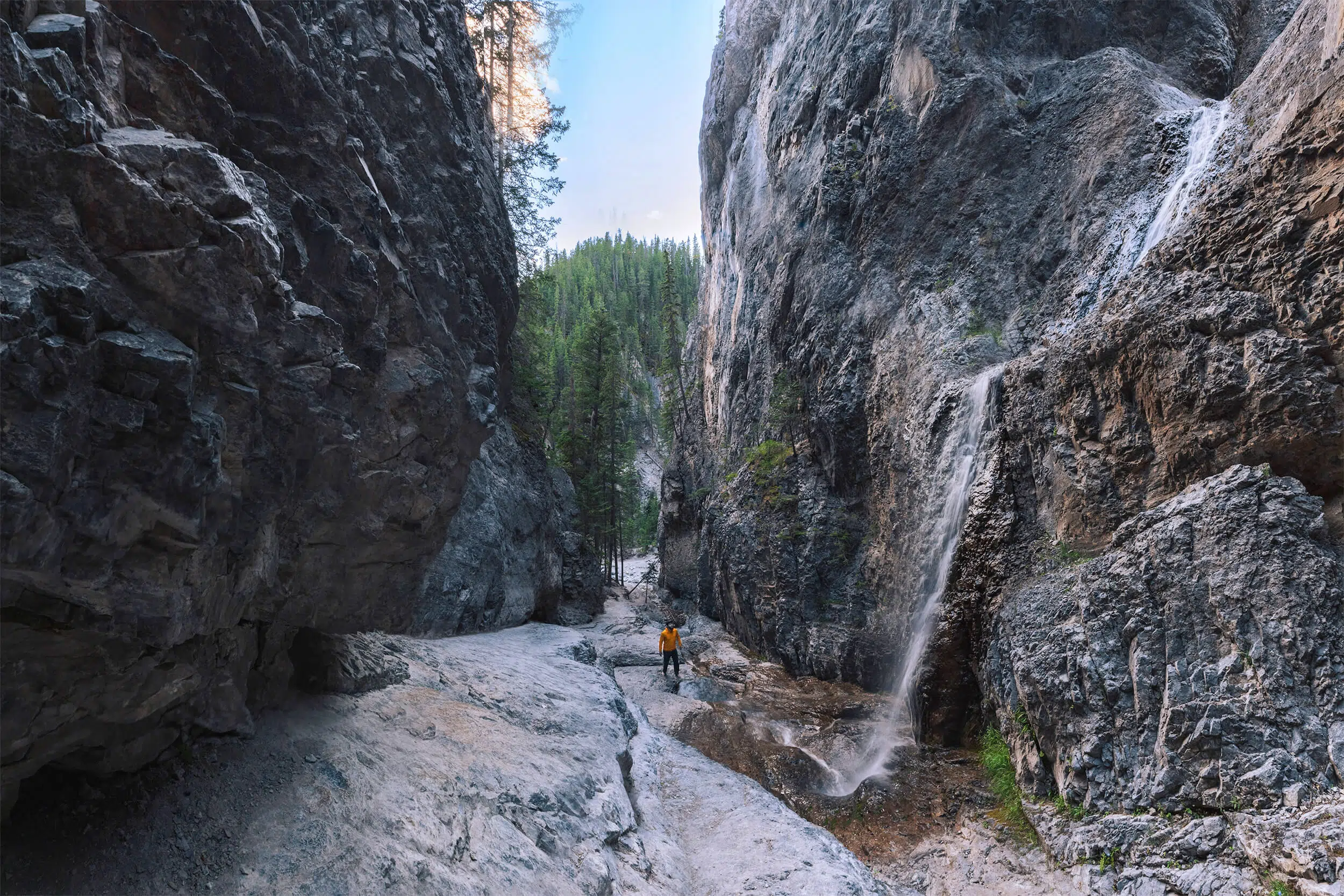
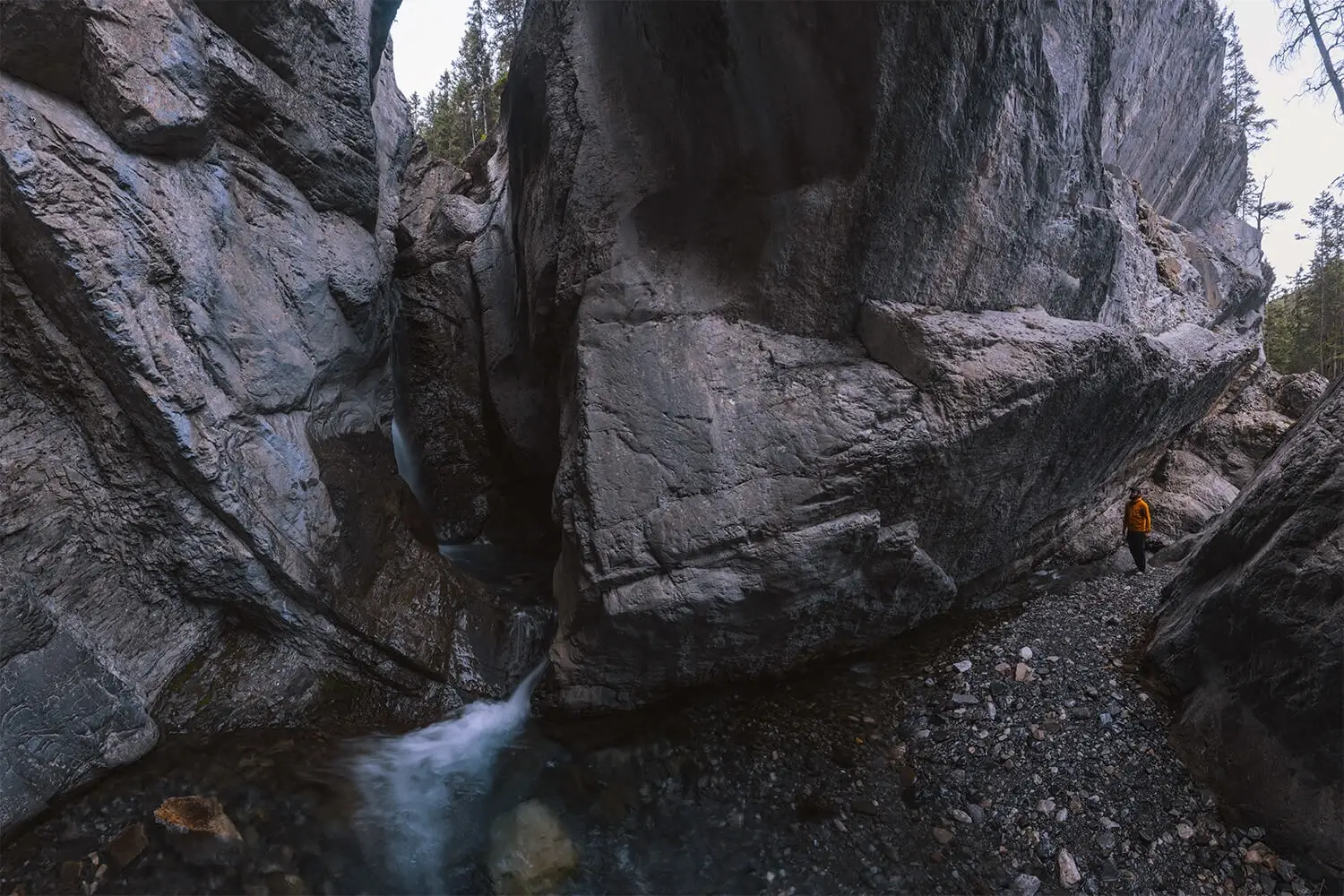
McGillivray Canyon
Distance: 5.6 km / 3.5 mi
Elevation Gain: 226 m / 741 ft
Hiking Time: 2 hrs
McGillivray Canyon is one of several gorgeous slot canyons carved out by once-gushing glacial meltwater not far from Canmore, and is in my opinion the best Canmore slot canyon. Today there’s not much more than a small stream most times of year, excepting the occasional spring flood. Unlike the other more well-known canyons in the area, you’re not going to run into a bus load of adventure-seeking tourists taking a tour through the canyon, nor are you likely to bump into many people at all if you’re lucky.
The walk up and through the woods alongside the canyon isn’t an easy one, as it rises and falls steeply via sometimes hard-to-follow trail, requiring small amounts of scrambling in certain sections. Eventually the tough slog through the woods ends with a quick and sharp descent into the canyon, and from here the hike is nothing but rewarding as the steep walls rise up on either side, arguably more dramatically and beautifully than any of the other canyons in the area. (The much more popular Grotto Canyon is probably deeper in some sections, but much shorter.)
Finally, the walk through the unique landscape ends with the oh-so-instagrammable views of the iconic McGillivray Canyon chockstone, stuck halfway down the canyon walls and looking like it could crash down at any moment. Walking underneath it is spooky. The McGillivray Canyon chockstone been suspended there for a long time though, and will be there long after any of us are gone.
The walk alongside and into McGillivray Canyon is one of those Kananaskis hikes that isn’t for everyone, but for those hikers looking for a bit of a challenge and to get away from the crowds, it’s a perfect choice.
Heart Creek Canyon
Distance: 5 km / 3.1 mi
Elevation Gain: 313 m / 1027 ft
Hiking Time: 1.5-2 hrs
The hike up alongside Heart Creek is mostly pleasant and gentle, and perfect for all kinds of hikers. It’s only near the end of the trail that the canyon walls really start to dramatically rise up and close in, and the turnaround point for most hikers leaves out the much more dramatic and hard-to-access canyon views further up.
While further upstream Heart Creek does drop down a series of gorgeous waterfalls bounded in on either side by right canyon walls, this section of Heart Creek isn’t accessible by hiking alone, and parts of the canyon must be rappelled down. Discover Banff Tours offers a fantastic canyoneering experience through this part of the canyon. During the hike highlighted on this blog however, I chose to push just slightly further upstream than the typical hiking endpoint in order to get a glimpse of a couple of the beautiful and rarely-photographed Heart Creek waterfalls.
Recommended Hiking Gear


Water is a must whenever I’m hiking, especially if the sun is going to be out. My favourite water filter I’ve used is the Katadyn BeFree 0.6L, which unlike other water filters I’ve used packs up really small and lightweight. For hikes where I know there won’t be any readily available water sources along the way, I make sure to bring my own. The Hydrapak Stow 1L bottle is my go-to, for the same reason that it’s made of a soft plastic that folds up and doesn’t take up any more extra space than necessary in my pack. Finally, Aquatabs are another great option for purifying water, with one tablet being suitable for one litre of water. I previously used the Grayl water filter while travelling internationally, and though I found its hard body more convenient for day to day use and easier to drink from, it has a little too much bulk for my fast-and-light style of hiking.


The secret to all my photos of gorgeous sunset and sunrise mountaintop views? A lot of hiking in the dark. And let me speak from personal experience when I say that the last thing that you want to happen when hiking is to be caught in the dark without a headlamp. I used the Black Diamond Spot 400 for years and it worked great – until I lost it on top of a mountain somewhere. The only downside to it was having to worry about the batteries dying, though there’s also a slightly more expensive version that has a rechargeable battery. Nowadays I’m using the Petzl Actik Core, which is a bit pricier than the more budget-friendly Black Diamond, but is also brighter, more comfortable (in my opinion), and has a hybrid power system that is rechargeable but can also take AAA batteries if needed.
You won’t see me using trekking poles on shorter hikes often – but on long hikes and backpacking trips, as well as certain scrambles, they are an absolute lifesaver. I’ve invested in a high quality ultra-lightweight pair of MSR DynaLock Ascent carbon poles which, while pricey, I don’t regret one bit. If you’re not entirely sure how much use you’re going to get out of a pair of trekking poles, the best budget-friendly option would be the Trekology Trek Z 2.0. Amazon does sell a lot of cheaper Made in China-style trekking poles for cheaper, but these usually are much much heavier and not worth buying.
All the best and most long-lasting cables and power banks I’ve ever owned have been Anker. I once had a phone cable from them that lasted me over three years of daily use! That’s why I keep an Anker PowerCore Essential 20K power bank on me. Like many people I use my phone for a lot of stuff when hiking (checking in with family, using online maps, taking photos, flying my drone) so I like to be prepared for that low battery warning by having a backup power source on me just in case.


The only socks I ever buy for myself are from Darn Tough, and I almost always make sure to wear them when hiking. After years of having no problems only wearing these comfortable and rugged socks for hikes, I accidentally wore a pair of no-name socks on a hike last year and ended up with blisters on both feet. Safe to say I’m back to sticking with the Darn Tough. And the best part? They have a lifetime guarantee, meaning that if they ever wear out you can send them back for a brand new pair. For hiking footwear I go between a pair of lightweight approach shoes for quick and dirty mountain ascents or anything involving scrambling and more heavy-duty boots for longer treks. I’ve worn a couple different versions of the lightweight but super durable Arc’teryx Konseal FL 2 approach shoes for a few years now and am very impressed with the durability. I also really like the thick toecap that keeps me protected every time I stumble into a root or large rock. For longer, tougher, or muddier treks I rely on my LOWA Camino EVO GTX, which I find insanely comfortable and made of very high quality.


I wear my Ar’teryx Gamma Lightweight Pants on every single hike I go on, and on many days when I’m not hiking. After several years of abuse they are still holding together extraordinarily well, with only a few small holes from where I’ve fallen down and some slight stains from being repeatedly coated with mud. They’re lightweight, breathable, and super comfortable. For lightweight and breathable hiking tops I’m a big fan of both the Patagonia Capilene Shirt and the MEC Core Shirt. My Arc’teryx Squamish Hoody shows up in a lot of my photos. It’s super lightweight and packable, and does a great job of cutting the wind while also being pretty breathable. I also have an Arc’teryx Atom Hoody and Arc’teryx Beta LT that I pull out for cooler or wetter conditions.